Geography
Geography at CVPS
Geography Progression of Skills
Curriculum Intent
What do we want to achieve with our Geography curriculum?
The aim of our Geography curriculum is to give children at CVPS the opportunity to become geographers, developing their enquiry skills and locational understanding through the use of purposeful planning that is built upon each year. At CVPS, we believe that Geography helps to provoke and provide answers to questions about the natural and human aspects of the world. Children are encouraged to develop a greater understanding and knowledge of the world, as well as their place in it. Children will, as geographers, be fascinated about the world around them, understand and accept other cultures and people around the world, conscientious in their understanding of human’s responsibility to protect the planet, see how the planet has learned and changed due to human’s actions, and be aware of careers within a geography field.
The national curriculum for geography aims to ensure that all pupils:
- develop contextual knowledge of the location of globally significant places – both terrestrial and marine – including their defining physical and human characteristics and how these provide a geographical context for understanding the actions of processes
- understand the processes that give rise to key physical and human geographical features of the world, how these are interdependent and how they bring about spatial variation and change over time
- are competent in the geographical skills needed to:
- collect, analyse and communicate with a range of data gathered through experiences of fieldwork that deepen their understanding of geographical processes
- interpret a range of sources of geographical information, including maps, diagrams, globes, aerial photographs and Geographical Information Systems (GIS)
- communicate geographical information in a variety of ways, including through maps, numerical and quantitative skills and writing at length.
Curriculum Implementation
How will this be achieved?
At Clayton Village Primary School, our children will develop a deep knowledge of both the physical and human geography of the local environment, the UK and the wider world. It is essential that our children develop a meaningful understanding of place, including the positioning of Clayton and Bradford within the wider world.
The progression of Geography skills, knowledge and understanding are divided into the following areas of learning:
- Substantive Knowledge which is underpinned by an enquiry question
- Declarative Knowledge (knowing ‘what’)
- Procedural knowledge (knowing ‘how’)
- Disciplinary knowledge (how we know and revise what we know)
- Flash back and flash forward
Each of these areas of learning are revisited during each new unit of work, building on prior learning and effectively developing the skills, knowledge and understanding to become an effective geographer. Our Geography curriculum aims to excite the children and allow them to develop their skills as geographers. We plan visits and visitors to provide first-hand experiences for the children to support and develop their learning within the Geography unit they are learning about. We recognise that to have impact, the visits must be clearly linked to the geography knowledge to be acquired, providing the opportunity for children to better understand the knowledge whilst applying geographical skills such as using maps.
Unit Structure & Lesson Structure
As with all afternoon lessons at Clayton Village Primary, geography is taught in blocks (approximately 10 hours per block for KS2 and Y2 and 4 hours for Y1). As a school, we have designed our own curriculum (following the NC as a guide). Children gain geographical knowledge through reading to enable them to answer key question drivers and then complete learning activities which develop their geographical skills and techniques.
Over the Key Stage phase, each year group will cover three units of geography over the year. Each unit will be delivered over a full term, equating to approximately twenty hours of study. The geography lead plans how this is covered during the term, by creating a LTP to ensure coverage. This will be communicated and agreed with the class teachers prior to the commencement of the new term. Each unit will cover the four key strands of the national curriculum: locational knowledge, place knowledge, fieldwork and human and physical knowledge.
Learning begins in Reception and Year 1, where children learn the component location knowledge of Clayton, Bradford and the UK, such as the names of the counties, cities and key human features. In Year 6, this culminates in the development of a rich geography schema, encompassing, for example, a deep understanding of biomes and how the UK has changed over time.
Essential geographical concepts such as the features of rivers, earthquakes and factors affecting settlement location are taught by focusing on specific locations and regions. This allows invaluable comparisons to be made between the UK and other areas of the world.
The following structure for lessons is used for our Geography units:
- Where in the world is…?
- What are the physical features and physical processes of…?
- What are the human features and human processes of…?
- Who lives in…? What is it like to live in…?
- Where would you rather live? (country/area studying) or (somewhere previously studied/Bradford)? (not in Autumn)
- Answer the enquiry question
Our knowledge-rich geography curriculum is taught according to the following whole school long term plan for geography:
| Autumn
Local/British/UK |
Spring
Europe |
Summer
World |
|
| Reception | Draw information from a simple map – explore different maps and then create a basic map of the classroom, find their way around school and create a map of the areas around school
Local walk – make basic observations about the local environment (Clayton)
Discuss and compare homes in different parts of UK/ the world
Look at a map of England – learn and use recently learnt vocab ‘land and sea’ |
Discuss the importance of recycling and looking after our world and the effect of pollution and ways we can help save the world
Investigate the world and its many countries Ask questions and learn about different types of transport and countries Investigate different destinations – weather, location, human and geographical features and how we can get there from the U.K Know similarities and differences between difference religious and cultural communities in this country Know similarities and differences between the natural world around them and contrasting environments |
Draw information from a simple map – explore maps of Thornton Hall farm before the visit and draw out information, create a map of the farm from memory
Explore the natural world around them – outdoor play and exploration, visiting the pond, planting seeds, observing changes over time (butterfly lifecycle and plant growing) Describe what they see, hear and feel whilst outside – on the farm and Summer nature hunt
Look at a map of the World – learn and use recently learnt vocab ‘earth and space’ |
| Fieldwork | Three local area (or school grounds) walks a year.
Each walk needs to use the ‘10 steps’ idea from Jon Canell. After each 10 steps the children will focus on a sense (what can they see?). Photos to be taken, items to be collected. Create a linear map with this. A walking stick is also another idea – add items (including pictures) in the order they were seen/heard. VLOG your findings to share with the other MAT schools. |
||
| Year 1 | What is life like in Clayton?
Country: England (Our School/Clayton) |
What is the weather like in the UK?
Country: England, Scotland, Wales, Northern Ireland |
What does our world look like on a map?
Country: World – Continents and oceans |
| Fieldwork |
Use drawings or printed pictures. Not drawn to scale.
|
||
| Year 2 | What does Bradford look like on a map?
Country: England (Bradford) |
What is it like to live near the coast? (Filey)
Country: England, Filey
|
How is Bradford different from Newfoundland & Labrador?
Country: Canada – Newfoundland and Labrador (North America)
Non-European Study: near the coast |
| Fieldwork |
|
||
| Year 3 | How can we make our area more environmentally friendly?
Country: England (Yorkshire) |
Why do people live near Volcanoes? (Mount Vesuvius/Pompeii)
Country: Italy |
Why are rivers important to us all? (Amazon River)
Country: Brazil (South America)
|
| Fieldwork |
|
||
| Year 4 | How has the Mersey River changed?
Country: England (Liverpool) |
What is life like in the Alps?
Country: France
|
What attracts tourists to China?
Country: China (Asia)
|
| Fieldwork |
|
||
| Year 5 | How do settlements in the UK vary?
Country: Wales (Anglesey) |
How has Norway become the most sustainable country in the world?
Country: Norway, Oslo
|
Would I prefer to live in Europe or Oceania?
Country: Australia (Oceania) |
| Fieldwork |
|
||
| Year 6 | Why do people climb Ben Nevis?
Country: Scotland |
Who lives in Antarctica?
Country: Antarctica (Antarctica) |
How is life changing for Kenyans?
Country: Kenya (Africa) |
| Fieldwork |
|
||
Throughout the units of geography, children will: be taught to develop their enquiry skills, learn how to use maps and explore key physical and human features and processes. Class teachers will carefully plan for the use of visits and visitors to complement and enhance the teaching of geography. At the beginning, midpoint and endpoint of each Geography unit, children will be asked to demonstrate their understanding by showing studied locations on a map and sharing comparisons to previous locations studied. At the end of the unit, children will be asked to demonstrate their learning and understanding (answering the enquiry question) through a piece of extended writing or oral presentation. Fieldwork from reception to Year 6 has also been mapped out and progression for this has been planned throughout. In Reception, children will go on a local area walk in Autumn, Spring and Summer and in Year 6, children will take part in an orienteering event with other schools within the academy.
Knowledge Organisers
Each unit of work has a bespoke knowledge organiser which helps our children understand the similarities and
differences of areas studied through the human and physical geography of that region. Knowledge organisers for each unit support pupils in building a foundation of factual knowledge by encouraging recall of key facts, vocabulary and maps. These will be introduced to the children at the start of each unit and continue to use these within each lesson. Low-stake quizzes and retrieval tasks will be used in the classroom to help children to recall key facts and make links with previous learning. Knowledge organisers are also used as a pre-teaching tool to support pupils with SEND and EAL.
The knowledge organisers are put on our learning platforms so that they are available to children and parents to help support pre and post learning learning and as a revision guide. Children are trained to use these knowledge organisers in class so that they are familiar with their layout and purpose. The knowledge organisers are used during the 2-week block of geography at the start of each geography lesson as part of a low stake, high threshold quiz.
Curriculum Impact
The impact of the teaching and learning of Geography will be demonstrated as follows:
- Children will know more, remember more and understand more about Geography.
- Children will understand and use location knowledge, place knowledge, physical geography, human geography (declarative knowledge)
- Children will understand and use geographical skills and fieldwork (procedural knowledge).
- Children will use a variety of skills to understand what we know including: asking and answering questions, collecting and interpreting, analysing and communicating and evaluating and debating (disciplinary knowledge).
- The large majority of children will achieve age related expectations in Geography.
- As geographers, children will learn lessons from geographers to influence the decisions they make in their lives in the future.
Formative Assessment will be used to determine children’s understanding and this will be summarised at the end of the year to inform the class teacher and Geography Subject Leader of the numbers of pupils working below, at and above age-related expectations. The completed summary will be shared by the class teacher. To make these assessments, class teachers will use children’s understanding in relation to Knowledge Organisers, work in the children’s books and informal ongoing classroom assessments and judgements.
Spiral Curriculum
Throughout the teaching of Geography, pupils will;
- Return to the key concepts again and again during their time in primary school.
- Deepen their understanding with each revisit as key concepts are covered with greater complexity.
- Utilise prior knowledge so they can build upon previous foundations, rather than starting again.
- Make comparisons between locations studied.
Our Aims at CVPS
Aim High
- Develop and enhance English and Maths’ skills through Geographical studies
- Preparing pupils for an ever-changing world.
- Use a wide range of ICT to support subject investigations and enquiries.
- Topical and emotive topics that deals with real issues
- Open ended questions to inspire a curiosity and fascination about the world and its people
Be Respectful
- Creates a sense of place, belonging, identity, purpose
- Equips children with an understanding of diverse places, people, resources and environments around them and the wider world
- Multi-sensory approaches
- SEND approaches used inc. use of resources and adults
- A variety of learning styles is used: visual, audio and kinetic
- Whole-class teaching methods, enquiry based group work, individual, pair, class and group work
- Build on empathy of others so that our pupils appreciate the diversity of our Britain and those who call it home
- Understand our world is continuously changing and we need to look after our environment to help for the future.
Create Happy Memories
- Plan a variety of visits and visitors.
- Enquiry, investigation, problem solving and decision making central to high quality learning in Geography
- Use a variety of resources to enhance geography learning
- Develop, enhance and apply geographical enquiry
- Pupils are taught through discussion, practical activity, games, investigations, problem solving, research, role-play and recording.
Key concepts for our geography topics
We have designed key concepts which our children will immerse themselves in during their study of geography. In KS1, they will focus on five key concepts (1, 2, 4, 6, 7 and 8). KS2 will cover all seven key concepts.
The eight key concepts listed below aim to help improve the geographical knowledge of our children but also to allow an opportunity to compare and contrast the area studied – allowing skills and knowledge to be recapped and revised throughout our children’s learning journey. (To facilitate comparisons, we have a bank of our bespoke knowledge organisers to be referred back to). We have chosen these areas and place of study not only as they fit in with the statements within the NC, but also because they are based on the relevance of the Hollingwood curriculum. Furthermore, each of our units of study have a number of question drivers for the children to focus on and which they should be able to answer by the end of each unit of study. Question drivers are present on the bespoke knowledge organisers for each unit so that children have a quick overview of the facts.
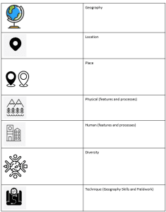
- Location (declarative knowledge)
Within locational knowledge, our children will locate the area of their study within the wider world and to be able to explain the position of such place in relation to: latitude, longitude, Equator, Northern Hemisphere, Southern Hemisphere, the Tropics of Cancer and Capricorn, Arctic and Antarctic circle and time zones.
- Physical Features (declarative knowledge)
Physical features like seas, mountains and rivers are natural. They would be here even if there were no people around. In KS1, children will develop their basic geographical vocabulary of key geographical features including: beach, cliff, coast, forest, hill, mountain, sea, ocean, river, soil, valley, vegetation, season and weather. For KS2 the children will be able to describe and understand key aspects of: physical geography, including: climate zones, biomes and vegetation belts, rivers, mountains, volcanoes and earthquakes, and the water cycle.
- Physical Processes (declarative knowledge)
After children have learned (concept 1) where their area of study is, they will focus on a physical feature which that place has. Physical processes are the natural forces that change Earth’s physical features, including forces that build up and wear down Earth’s surface. They will then consider the physical processes that may occur as a consequence of a physical feature. For instance, if the children have learned about rivers in their area of study, they would then look at flooding.
- Human Features (declarative knowledge)
Human features like houses, roads and bridges are things that have been built by people. Human features are also things such as language, religion, political systems, economic systems and population distribution. In KS1, children will use basic geographical vocabulary to refer to: key human features, inc: city, town, village, factory, farm, house, office, port, harbour and shop. In KS2, children will study human geography, including: types of settlement and land use, economic activity, the distribution of natural resources including energy, food, minerals and water
- Human Processes (declarative knowledge)
Human geography looks at the impact and behaviour of people and how they relate to the physical world. After children have learned (in concept 1) where their area of study is, they will focus on a human feature which that place has. They will consider the human processes that may occur as a consequence of a human feature. Human processes link with the physical features of the area studied as well as the human features.
- Diversity (declarative knowledge)
We have included diversity within our geography curriculum to tailor our areas of study to the needs of our children and to help them to understand the diversity of all the areas studied.
- Place (declarative knowledge)
After children have learnt key knowledge in relation to location, human features and processes, physical features and processes and diversity they will be able to recognise similarities and differences about places which are studied.
- Techniques (Geography skills/Fieldwork) (procedural knowledge)
In KS1, we expect our children to use world maps, atlases and globes, simple compass directions, aerial photographs and develop their observational skills. In KS2, the children will continue to use maps, atlases, globes and further their
techniques through the use of 8 points of a compass, 4 and 6 figure grid references along with symbols and keys on a map.
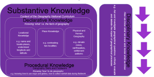
Substantive Knowledge (declarative and procedural knowledge)
Technical skills & subject knowledge:
Children gain geographical knowledge through lessons to enable them to answer enquiry questions; then complete learning activities to develop their geographical skills.
Breadth of study: in addition to discrete lessons, additional aspects of geography are taught through the wider curriculum. All year groups take part in a careers week each year which gives the children an opportunity to learn about a variety of jobs including those in the geography field. We have also selected guided reading books in KS2 which focus on the environments and creating a sustainable future.
Developing vocabulary: our aim is to ensure that our children are familiar with frequently occurring geographical words that appear in various contexts and topics (including terms and concepts). These will be identified through the knowledge organisers.
Disciplinary Knowledge
We aim for our children to have a deepening awareness of how geography is around us and a growing understanding of what it means to get better at geography through:
- Asking and answering questions
- Collecting and interpreting
- Analysing and communicating
- Evaluating and debating
The Relationship of Different Kinds of Knowledge in Geography
Key Symbols